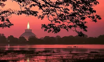
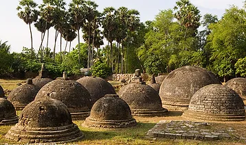
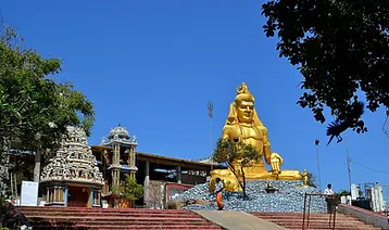
Anuradhapura is one of Sri Lanka’s ancient capitals, and its ruins of ancient Lankan civilization are well-known and visited by tourists. It served as the island nation’s capital from the fourth century B.C. to the early eleventh century A.D. Throughout this time, it was one of the most reliable and long-lasting hubs of urban life and political power in all of South Asia. Over forty square kilometres (16 square miles) of land is taken up by monasteries surrounding the ancient city that is sacred to Buddhists everywhere. Anuradhapura holds a special place in Hindu mythology as the legendary capital of the Asura king Ravana in the Hindu epic Ramayana.
WE ARE
TAPRORABANA
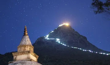
ADAMS PEAK
Located in the middle of Sri Lanka, the conical mountain Adam’s Peak rises to a height of 2,243 metres (7,359 feet). A 1.8 m rock formation near the top of Sri Pada is revered by Buddhists, Hindus, and Muslims as the “sacred footprint” of Buddha, Shiva, or Adam.
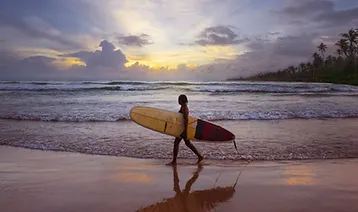
ARUGAM BAY
Located in the southeast corner of Sri Lanka, Arugam Bay faces the Indian Ocean during the dry season. You’ll find the bay 320 kilometres due east of Colombo. Those who enjoy surfing and vacationing there will find it to be a prime spot. Attracting budget travellers has helped the area slowly recover. only through individual effort. The main road through town has still not been repaved. Access to the area will be bolstered by the currently ongoing road construction. However, in Arugam Bay itself, not much has altered. There has been no aid from the government or international organisations as of May of 2009. An exception is uncoordinated support for fishing communities as well as many schools rebuilding programmes, resulting in a continuation of providing only separatist schools for each community.
BENTHOTA
Bentota, a city on the southern tip of the Galle District in Sri Lanka’s Southern Province, is known for its beautiful beaches. Visitors flock to see the historic district. Tourists from other countries seem to flock there in droves. The name comes from an old myth about a demon named Bem who supposedly ruled over the river (tota = river bank) during the reign of the kings. Bentota is home to a select number of hotels that have earned international renown. Aida, a renowned jeweller from Sri Lanka, calls this place home. Bentota also provides the age-old practise of Ayurveda for its customers. Bentota is well-known for its toddy, which is a popular drink. A coconut nectar-based alcoholic drink. Between 25,000 and 50,000 people call the city home.
BATICCALOA
Located in Sri Lanka’s Eastern Province, Batticaloa is a major urban centre. The Eastern University of Sri Lanka is located here. It’s an island off the east coast, 69 miles south-east of Trincomalee.
BUNDALA
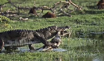
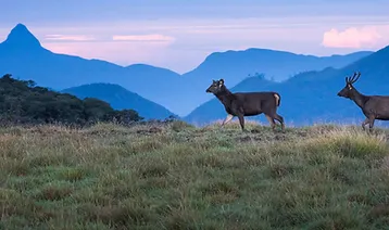
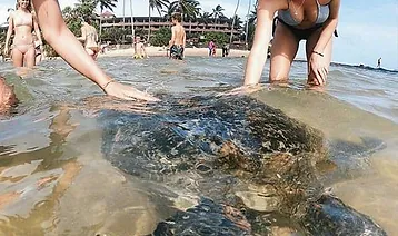
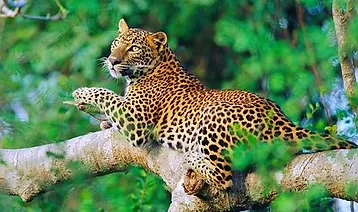
Approximately fifteen kilometres east of Hambantota, Bundala National Park protects an important area of coastal wetland known for its abundant aquatic (and other) birdlife, making it one of Sri Lanka’s foremost destinations for birdwatchers. Leopards are just one of many animals that call this park home; there are also large populations of elephants, marsh crocodiles, estuarine crocodiles, turtles, and more. Bundala National Park, located east of Hambantota, stretches along the coast and is a great place to get your fix of wildlife in a hurry. In just four hours on a jeep, we saw elephants, 8-foot crocodiles, giant squirrels, and flamingos. The best time to go on a safari is in the afternoon during the dry season (December to May).
Balangoda
Located on the Colombo–Batticaloa Highway, 143 kilometres (89 miles) from Colombo and 43 kilometres (27 miles) from Ratnapura, the large town of Balangoda in Ratnapura District, Sabaragamuwa Province, Sri Lanka is governed by an urban council (A4). This city ranks high among Sabaragamuwa Province’s major centres. Balangoda has a population of 16,875 and an area of 16.2 km2 as of the 2001 census (4,000 acres).
In particular, the discovery of late Quaternary Hominini skeletons at Balangoda is of interest (the earliest reliably dated record of anatomically modern humans in South Asia). In addition to Balangoda Ananda Maitreya Thero and Sirimavo Bandaranaike, the Prime Minister of Sri Lanka (and the first female head of government in the world,1960–65, 1970–77, and 1994–2000).
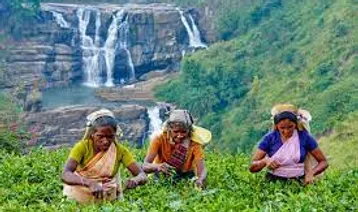
Balangoda sits atop the Sabaragamuwa Mountain Range in Sri Lanka’s central hilly region. Farming (vegetables, fruits, and spices), growing rice for mostly local use, growing tea as a cash crop for international markets, and mining for gems are the main ways people in this area make a living.
BERUWALA
Beruwela is a small tourist town on Sri Lanka’s southwest coast. Since Beruwela is a Sinhalese word, it is the source of the name (the place where the sail is lowered). It was here that Arab merchants established the first permanent Muslim settlement on the island, sometime in the eighth century. There is still a sizable Sri Lankan Muslim community in town, and the “China Fort” is where many of these gem traders make their homes. Built by Arab traders on a rocky peninsula above the town, Msjid-ul-Abrar is a prominent feature of Beruwela and is the oldest mosque in Sri Lanka.
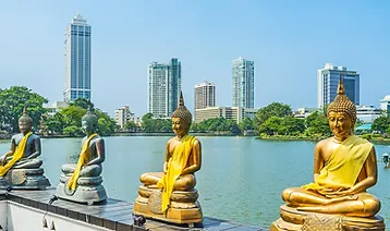
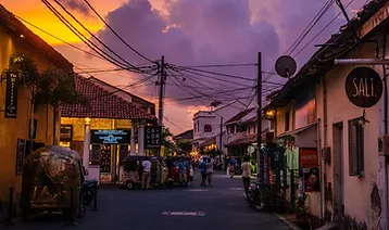
COLOMBO
It is believed that the classical Sinhalese name Kolon thota, meaning “port on the river Kelani,” is the source of the name “Colombo,” which was first used by the Portuguese in 1505 when they established a settlement there. The Sinhalese name Kola-amba-thota, which translates to “Harbour with leafy mango trees,” has also been proposed as a possible origin. 2,000 years ago, ancient merchants passed close to Colombo on East-West Sea trade routes, making it a major port city known to ancient merchants. It wasn’t until 1815, when Sri Lanka was ceded to the British Empire, that Colombo became the island’s capital, and it remained the capital even after independence in 1948. Even though the government is now in Sri Jayawardenepura Kotte, Colombo has been known as the commercial capital of the country since 1978.
Belihull oya
Belihuloya is a small town in Sri Lanka’s Sabaragamuwa Province. It is located in the Ratnapura District. Located roughly 150 km (93 mi) south-east of Colombo, at an elevation of 616 m (2,021 ft), it offers spectacular views of the surrounding area. This hilly region connects the dry and wet zones, as well as the high and low country, in terms of climate. Its name, Belihuloya, comes from the Belih Oya (Oya being the Sinhala word for river), which runs through the area.
ELLA
Some of Sri Lanka’s most breath-taking scenery can be found in Ella. This small town serves as a convenient starting point for many treks into the surrounding countryside, and it is only 8 kilometres from Bandarawela. If you want a taste of Ella’s breath-taking scenery, all you have to do is step into the garden of the Grand Ella Motel (formerly the Ella Rest House) and you’ll feel like you’ve reached the end of the earth. The entrance to
the Ambiente Hotel is dramatic, reminiscent of a scene from a film, with its wide doorway opening out to the mountains. Ella has a wide variety of scenic hikes to choose from, including the Ella Gap, Ravana Ella Falls, Little Adam’s Peak, and Bambaragala Peak.
Hambantota, a small town on Sri Lanka’s south-eastern coast, is a prime example of rural life in the country. As the seat of government for Sri Lanka’s Southern Province, Hambantota is an important economic and cultural hub.
GALLE
Galle (“Gaul,” and in Sinhalese IPA: [al]) is a town on the southwestern tip of Sri Lanka, 119 km from Colombo. Before the Portuguese arrived in the 16th century, Galle was known as Gimhathiththa, and it served as the island’s primary port. During the eighteenth century, when the Dutch colonised Sri Lanka, Galle flourished. Starting at Gongala Kanda, the Gin River Ganga flows through the communities of Neluwa, Nagoda, Baddegama, Thelikada, Wakwella, and Ginthota before finally meeting the ocean. The longest bridge in Sri Lanka spans the Wakwella River in Wakwella.
HORTON PLAINS
The Horton Plains National Park in the highlands of Sri Lanka is known as Horton Plains or “Maha-Eliya” in the local Sinhala language. Located at an elevation of over 2,000 metres in the island’s central highlands, the region experiences a much cooler and windier climate than the lowlands, with an annual mean temperature of 16 degrees Celsius, compared to the 26 degrees Celsius found along the coasts. The area was named for Lady Anne Horton in 1834, after the wife of Ceylon’s governor, Sir Robert Wilmot-Horton.
HIKKADUWA
Located on Sri Lanka’s southern coast, Hikkaduwa is a sleepy little town. It’s about 20 kilometres north-west of Galle in the Southern Province. The beach and coral reefs at Hikkaduwa is well-known attractions. Telwatta, Paraliya, Dodanduwa, Kahawa, and Rathgama are just some of the affected villages. The location is conveniently located along the well-known Galle Road, which leads from Colombo to Galle. Its primary draw for visitors is the fantastic beach, where they can swim, snorkel, and bask in the sun.
KALKUDAH
Known in Tamil as Kalkudah (pronounced Kal-Kuda), Kalkuda is a coastal resort town in Sri Lanka’s Batticaloa District, about 35 kilometres northwest of Batticaloa. The 2004 Indian Ocean Tsunami and the Sri Lankan Civil War caused a significant drop in tourism to the country. A short distance separates Pasikudah and Kalkudah.
JAFFNA
The Northern Province of Sri Lanka is headed by Jaffna, also known as Yazhpanam. Sri Lankan Tamils, Sri Lankan Moslems, and Portuguese Burghers make up the majority of Jaffna’s population. As a result of the ethnic conflict that began in the 1970s [1], the LTTE drove almost all Sri Lankan Muslims out of Jaffna in the 1990s, and the city is now dominated by Tamils and the military
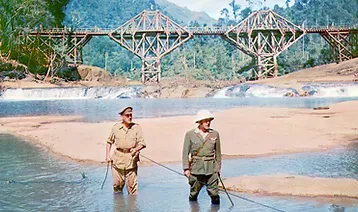
KITHULGALA
Western Sri Lanka is home to the small town of Kitulgala. There are two annual monsoons, making this area of the country’s wet zone rainforest one of the wettest. However, the first three months of the year see the greatest activity, particularly in February, the driest month. White-water rafting begins a few kilometres upstream from Kitulgala, on the same Kelani River that was used in the filming of the Oscar-winning “The Bridge on the River Kwai,” although nothing of the bridge itself remains.
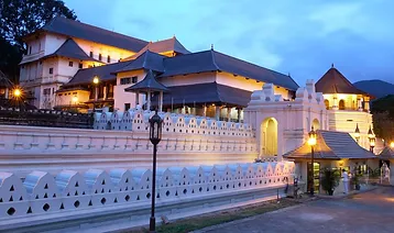
KANDY
The city of Maha Nuvara (Senkadagalapura), in the geographic centre of Sri Lanka, is known in English by its Sinhala name, Kandy. Both the Central Province and the Kandy District call this city their capital. It’s nestled among hills in the Kandy Valley, which cuts through a region of mostly tea plantations in the tropics. If you’re visiting Sri Lanka, you should definitely check out Kandy. Kandy serves as the capital and the religious centre of Sri Lanka. Kandy serves as the provincial and district capital of Central Province.
KATUNAYAKA
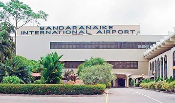
Katunayake, a town, is located on the western coast of Sri Lanka, not far from Negombo and the island’s commercial capital, Colombo. Bandaranaike International Airport, Sri Lanka’s primary international airport gateway, is located there. A sizable area was set aside for the establishment of a free trade zone after a government shift in 1977 led to an open economy policy. This has boosted the country’s economy and provided employment for a large number of young people.
KALPITIYA
The western peninsular area of Kalpitiya in the Puttalam district of Sri Lanka is remarkably untouched by tourism, despite its natural beauty. However, for those fortunate enough to travel there, there is a wealth of experience to be had! Visitors can get a true glimpse into working life outside of the city, as the locals’ days are dominated by the small, close-knit fishing community. After witnessing the return of the night fishing boats in the morning, a trip to one of the fish markets allows you to select your evening meal from the day’s fresh catch. There are some fascinating remnants of Sri Lanka’s colonial past in the town’s Dutch Fort and St. Peter’s Kerk church. One can enjoy the coast by taking a boat ride up the lagoon, a canoe trip down the river, or by riding a 4WD jeep along the deserted sand dunes that separate the ocean from the lagoon for a truly unforgettable view of the vibrant sunsets.
Mannar Island is part of Mannar District, Sri Lanka. It is linked to the rest of Sri Lanka by a causeway
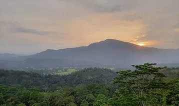
Knuckles Mountain
The Knuckle Mountain Range, to the north-east of Kandy, is home to the Knuckle Mountain Range. From certain vantage points in the Kandy District, the range’s name comes from the way its western recumbent folds and peaks look like the knuckles of a clenched fist. While the early British surveyors gave the region this name, the Sinhalese locals have always known it by another name: Dumbara Kanduvetiya, which means “mist-laden mountain range” (Cooray, 1984). Not only is the range beautiful to look at, with its striking landscapes often shrouded in thick layers of cloud, but it also holds great scientific interest. It has the same climate as the rest of Sri Lanka, but in miniature.
Nilaveli-Trincomalee
Located in the Trincomalee District of Sri Lanka, about 20 kilometres north-west of the city of Trincomalee, Nilaveli is a popular tourist destination. The 2004 Indian Ocean Tsunami and the Sri Lankan Civil War caused a significant drop in tourism to the country.
Matara
Matara was originally a part of the kingdom of Ruhana, one of Sri Lanka’s three dynasties (Thun Sinhalaya). According to the Mahawansa, the first Indians to arrive in the island country established themselves along the banks of the Nilwala river. Attestations to the long reign of Sinhala kings over Matara include Dondra (Devinuwara) and Weherahena, among others. Also constructed by long-gone kings, the town’s central temple is now revered by local Buddhists. Matara fell under the control of the Portuguese in the 16th century and the Dutch in the 18th century
Located in the Batticaloa District of Sri Lanka, Pasikudah (also spelled Pasikuda) is a popular beach destination. Pasikudah and Kalkudah are only a few kilometres apart; they used to be popular tourist destinations.
Negombo
About 37 kilometres north of Colombo is the town of Negombo, Sri Lanka, with a population of around 65,000. It can be found about 7 kilometres from Bandaranaike International Airport at the mouth of the Negombo lagoon. Negombo is home to a small port and a thriving economy based on tourism and centuries-old fishing operations. The town also manufactures cinnamon, ceramics, and brass goods.
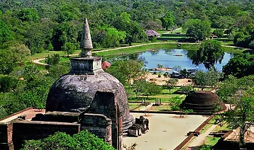
Polonnaruwa
Polonnaruwa is the second-oldest of Sri Lanka’s kingdoms. It became the country’s capital for the first time in 1070 CE, after King Vijayabahu I defeated the Chola invaders and united the island under a native ruler
Palmadulla
Upper and middle Nawadun Korale parishes make up the Pelmadulla Divisional Secretariat. It occupies a prime spot in the heart of Ratnapura city. It has the twelfth largest square footage of any divisional secretariat in the district. The park’s 14,674 acres make up 4.46 percent of the Rathnapura district and 0.22 percent of the island of Sri Lanka.
Nuwara Eliya
“City on the Plain (table land)” or “city of light” describes this town in Sri Lanka, known as Nuwara Eliya. Standing at an elevation of 1,868 metres (6,128 feet), it is one of Sri Lanka’s prime tea-growing regions. Pidurutalagala, Sri Lanka’s tallest peak, towers over the city below.
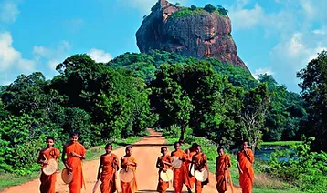
Sigiriya
An ancient rock fortress and castle/palace ruin, Sigiriya (Lion’s Rock), can be found in the central Matale District of Sri Lanka, surrounded by the remnants of an elaborate network of gardens, reservoirs, and other buildings. It is a well-known tourist attraction due to the presence of ancient frescoes that are strikingly similar to those found in India’s famed Ajanta Caves. One of Sri Lanka’s seven World Heritage Sites, the Sigiraya was constructed during the reign of King Kassapa I (AD 477–495).
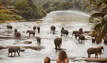
Pinnewela
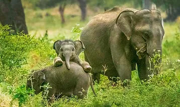
Located in the hills of central Sri Lanka, between the modern capital of Colombo and the ancient royal residence of Kandy, is where you’ll find the Pinnewela Elephant Orphanage. Located on a 25-acre coconut grove alongside the Maha Oya River, it was founded by the Sri Lanka Wildlife Department in 1975. The original goal of the orphanage was to provide a safe haven for the many baby elephants that were discovered in the jungle. About eighty-four elephants remain as of the year 2008.
Trincomalee
About 110 miles northeast of Kandy, you’ll find Trincomalee, a port city on Sri Lanka’s eastern coast. The city itself is located on a peninsula that separates the two harbours. It’s a major hub for the island’s Tamil community. In the past, this harbour was called Gokanna or Gokarna. It was very important to Sri Lanka’s maritime and international trade.
Puttalam
The arrival of the North Indian Prince Vijaya, around 2500 years ago, in Tammanna, in the coastal belt above Puttalam, is the earliest documented event in the history of this dry zone district. That’s what happened when his ship ran aground. Kuweni’s home, Thonigala, is located far within the territory. It’s possible that “Puttalam” is an anglicised version of the Tamil name Uppuththalam, in which “Uppu” refers to salt and “Thalam” designates the location where salt is manufactured. In the end, the name Puttalam emerged.
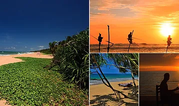
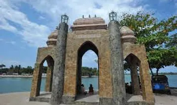
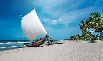
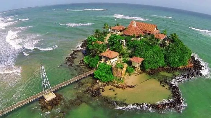
Weligama
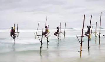
Located on the southern coast of Sri Lanka, Weligama is a fishing town in the Matara district. Weligama, named for the area’s sandy sweep bay, is also known as “Sandy Village.” Weligama is a popular tourist destination located 143 kilometres from Colombo and is home to a number of quaint hotels. It is best known for its traditional stilt fishermen and the nearby islet of Taprobane, on which the French Count de Maunay constructed his dream home.
Ratnapura
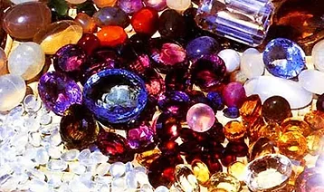
The town of Ratnapura and the district it is in both share the name Ratnapura, which designates the provincial capital of Sri Lanka’s Sabaragamuwa Province. Most Sri Lankans believe that the name comes from the Sinhala words “ratna” meaning gems and “pura” meaning city, but others have suggested that it is derived from the Portuguese word “rapadura” for jaggery, the palm candy traditionally produced in this region. The name Ratnapura can also be spelled as Rathnapura. About 101 kilometres south-east of Colombo, it is the hub of a well-established industry producing rubies, sapphires, and other precious stones. The town’s reputation rests not only on its gem mining but also on its rice and fruit production.
Yala PARK
Sri Lanka is home to a national park known as Yala. Of the total 979 km2 that make up the reserve, only the original 141 km2 are accessible to the general public. In 1894, it became a designated game sanctuary. While parkland makes up the bulk of the reserve, jungle, beaches, freshwater lakes and rivers, and scrubland are also present. This latter region is characterised by massive rocky outcrops. There is a wide variety of animals because of the variety of habitats.
Sinharaja
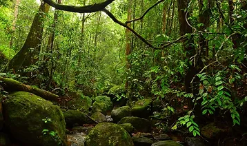
Sri Lanka is home to a number of national parks, one of which is the Sinharaja Forest Reserve. UNESCO has recognised its global significance by designating it as a Biosphere Reserve and a World Heritage Site. The inaccessibility of the hilly virgin rainforest, which is part of the Sri Lanka lowland rain forest ecoregion, protected it from the worst of commercial logging and led to its designation as a World Biosphere Reserve in 1978 and a World Heritage Site in 1988. The name of the reserve can be translated to mean “Lion’s Kingdom.”
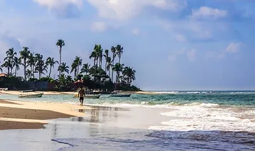
Unawatuna
Unawatuna is a popular tourist destination on Sri Lanka’s southern coast. Unawatuna, one of Sri Lanka’s best scuba diving spots, is also one of the country’s loveliest beaches. Sri Lanka is a great place to relax and enjoy the beach, scuba diving, surfing, and seafood the Sri Lankan way. Places like Jungle Beach, Roomassagla Hills, Kathaluwa Temple, and Galle Fort are worth checking out.
Wilpattu
In Sri Lanka, you can visit Wilpattu National Park. The natural, sand-rimmed water basins or depressions in this park that fill with rainwater are called “Willus,” and they are the park’s defining feature. It is situated in the dry zone of the lowlands along the northwest coast of Sri Lanka. The park is situated 26 kilometres north of Puttalam and 30 kilometres west of Anuradhapura (approximately 180 km north of Colombo). There is a wide variety of elevations within the park’s 131,693 hectares, from below sea level to 152 metres above. Wilpattu is dotted with lakes (Willu) and tanks, nearly sixty in total. Wilpattu National Park is both ancient and large, making it a prime example of Sri Lanka’s impressive network of protected areas. One of the reasons Wilpattu is so well-known is the large population of leopards (Panthera pardus kotiya) that live there. Until now, Wilpattu’s leopard population has remained a mystery.